Half Dome Day Hike
Yosemite National Park
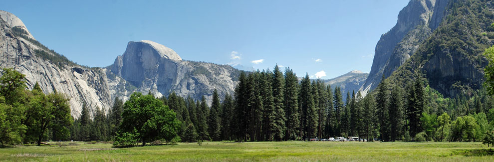
Hiking to the summit of Half Dome and returning to the valley floor in a single day is a substantial endeavor. Those who reach the top are rewarded with magnificent views of Yosemite Valley. For many, the achievement of such a formidable - and perhaps unnerving - adventure is something to be carried within them for the rest of their lives.
Half Dome Permit
You must have a permit to ascend Half Dome. Because the hike has become so popular, rangers have decided for safety reasons to limit the number of people making the climb to 300 each day. Permits are required when the handrail cables are up, usually late May through early October. Obtain a permit for yourself and a group up to 6 people through the permit lottery, beginning March 1.
Preparing for the Hike
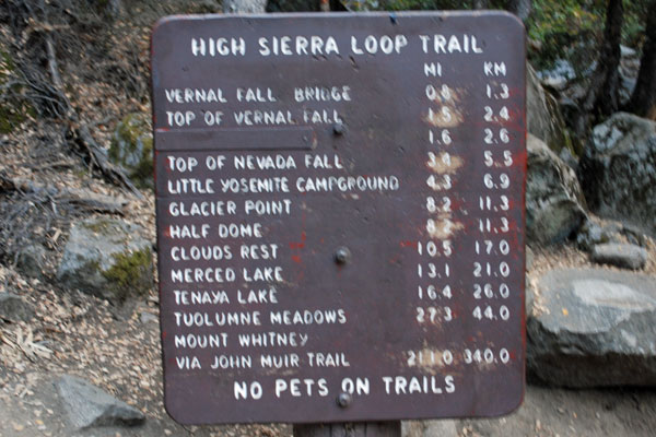
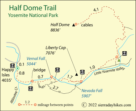
The hike from the valley floor to the summit of Half Dome is 16 miles round-trip, climbing 4,800 feet. Most hikers take 10 to 12 hours to make it to the top and back. Prudent hikers set out by sunrise or even earlier. Read and heed Yosemite's advice about ascending Half Dome: Half Dome Day Hike.
Half Dome Trailhead
Strenuous
16 miles
4,800 feet
Yosemite
The Half Dome Trailhead is at Happy Isles, which can be reached by walking from Camp Curry or taking the shuttle bus. At Happy Isles are restrooms, water, and interesting exhibits. Since the footbridge across the Merced River at Happy Isles was removed, hikers now cross the river on the same bridge the shuttle bus uses and then double back up the north side of the river to the official trailhead.
Happy Isles is the trailhead for hikers going up the Mist Trail to Vernal and Nevada falls as well as backpackers heading out on the John Muir Trail. It can be congested, but for those heading up Half Dome, an early morning start avoids the crowds.
Half Dome Trail
From the Happy Isles trailhead, climb steadily up the Mist Trail or John Muir Trail to the top of Vernal Fall and then Nevada Fall. The Mist Trail is shorter and steeper and can be very wet in early season. The John Muir Trail is often the safest choice for the return trip.
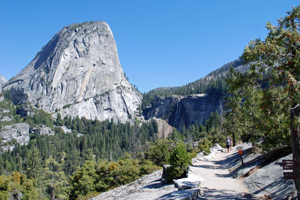
Liberty Cap and John Muir Trail, Alternate Route
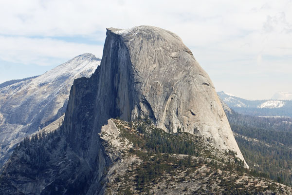
Both trails converge near the top of Nevada Fall. At that point hikers have ascended 2,000 feet. The trail levels out somewhat as it enters Little Yosemite Valley and then begins to climb again with switchbacks along Sunrise Creek. After a little more than 1½ miles the Half Dome Trail diverges from the John Muir Trail. After another mile the trail climbs a lower dome and then dips into a saddle below the cables. Permits are checked by rangers. Your permit group needs to stay together.
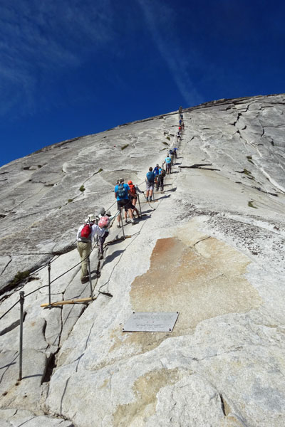
Cables Leading Up Half Dome
The final pitch up the cables is not as daunting as many imagine. The cables serve as handrails and wood slats are fastened across the rock at intervals, providing a secure place to rest your feet. Ascend with care and you will soon find yourself celebrating on the expansive summit of Half Dome.

Things to Know
- A permit is required to hike to the summit of Half Dome.
- Bring leather gloves to protect your hands on the cables.
- Restrooms are available at Happy Isles, the Vernal Fall Bridge, a short distance beyond the top of Vernal Fall, at the trail junction near the top of Nevada Fall, and at the Little Yosemite Valley campground.
- Drinking water is available at Happy Isles. Bring an ample supply of water and a water filter. Water is scarce beyond Little Yosemite Valley.
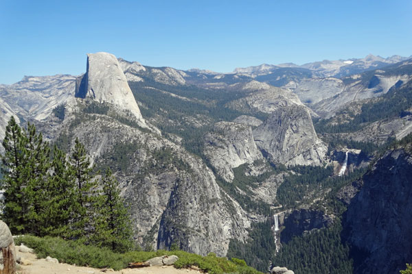
Half Dome, Nevada and Vernal Falls
Nearby Sierra Day Hikes
- Vernal Fall - hike up the Mist Trail to the top of the fall
- Bridalveil Fall - short walk to base of beautiful waterfall
- Lower Yosemite Falls - easy walk on paved trail to foot of falls
- Mirror Lake Loop - a 1-mile walk out to the lake
Other Nearby Trails
The Panorama Trail leads up from the top of Nevada Fall to Glacier Point. From there the Four Mile Trail descends to Yosemite Valley. It is a long, strenuous loop, but some hearty hikers might select the challenge. A good option is to book a seat on the tour bus to Glacier Point and then hike down the Panorama Trail to Nevada Fall and on into the valley via the John Muir or Mist trail.